The Definition of Surveying
(Based on the International Federation of Surveyors - FIG)
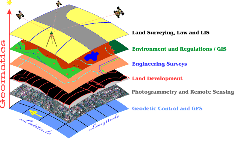
by Bob Morris at morris@adm.njit.edu
A surveyor is a professional person with the academic qualifications and
technical expertise
to practice the science of measurement; to assemble and assess land and
geographic
related information; to use that information for the purpose of planning
and implementing
the efficient administration of the land, the sea and structures thereon;
and to instigate the
advancement and development of such practices.
Practice of the surveyor's profession may involve one or more of the following
activities
which may occur either on, above or below the surface of the land or the
sea and may be
carried out in association with other professionals:
The determination of the size and shape of the earth and the measurement
of all data
needed to define the size, position, shape and contour of any part of the
earth's surface.
The positioning of objects in space and the positioning and monitoring
of physical features,
structures and engineering works, on, above or below the surface of the
earth.
The determination of the position of the boundaries of public or private
land, including
national and international boundaries, and the registration of those lands
with the
appropriate authorities.
The design, establishment and administration of land and geographic information
systems
and the collection, storage, analysis, and management of data within those
systems.
The study of the natural and social environment, the measurement of land
and marine
resources and the use of the data in the planning of development in urban,
rural and
regional areas.
The planning, development and redevelopment of property, whether urban
or rural and
whether land or buildings.
The production of plans, maps, files, charts and reports. In the application
of the foregoing
activities, surveyors take into account the relevant legal, economic, environmental
and
social aspects affecting each project.