Locating Objects By Relative Measurement
Or Baseline
Notes and Suggestions for Botanical Garden Surveyors
By Walt
Dunlap, Mapping Specialist, The New
York Botanical Garden © 2000 The New York Botanical Garden
No one says you have to use surveying instruments or high-tech methods to map objects. Depending on your need for accuracy, you may be able to use simple and straightforward methods that have been in use at least since the ancient Egyptians, accomplished land surveyors.
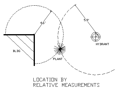
BG-Map automatically offers the convenience of adding
a plant using relative measurements, and this method is valid for adding
any object to a map. If you have two objects already mapped nearby, you
can swing your tape to the unknown point and plot
it at the intersection of the two distances. The illustration shows
these "swing-ties" taken from a building corner and a hydrant. Notice that
there are two points of intersection of the ties and that you must be careful
to note the relative position of the new object accordingly. You may do
this with a good sketch in the field book, so that when you return to the
office you don't have to rely on memory.
|
The accuracy of this method varies with several factors: first, the accuracy of the location of the already-mapped objects; second, the alignment of the 3 objects; third, the precision of the distances. Use objects that have acceptably firm locations and limit the use of just-located objects as measuring points. Try to create a broad-based triangle between the measuring points and the new object. If all the objects are in a straight line you will get the least reliable location. When measuring be sure to pull the tape horizontally tight and to measure from the exact same points: that is, the building corner depicted on the drawing, the top center of the hydrant and the approximate center of the plant. Adding a measurement to a third known object will give better accuracy to the new object's location. It will also probably create an overlap of the 3 circles when you swing the distances for your map. The most probable location of the object is in the middle of the overlap, unless it is very large, which is a good indication of an erroneous distance or other problem. |
| The illustration of the baseline method uses the prolongation of the building face as the baseline, but you may use any alignment between known objects where you can lay down or orient a tape measure. Assign a zero value to one end of the baseline, and determine the distance along the line to the right angle offset of the object to locate. By noting the distance along the baseline and by measuring at a right angle to the tape you can assign a unique location to the new object. The tricky part is the right angle. Right angle prisms can be used for this type of work. But, most often, the measurer stands astride the baseline facing the object, points his hands to both ends of the line, and claps them together in front in front of himself. This will show where a projected right angle would strike relative to the object. The measurer then adjusts his stance along the baseline to the appropriate point. With two people, one can hold at the object, and the other can swing the tape along the baseline to get a good visual estimate of the relation of two physical lines and better estimate the right angle location. | 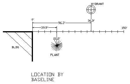 |